To view the map, expand the state or quarter you are working on and then click on Municipal Boundary in the tree. The map displays all of the municipal and county boundaries for the current state and maps out a point for each policy in the report file. The darker shaded areas are city boundaries. Each point is a graphical representation of the matched address in relation to municipal boundaries.
When the map is loaded, you can select a label to describe each address point. You can change the label to display policy number, municipal code, municipal name, or address.
All policies may not be displayed on the maps if there is not enough room to display them. Float your cursor over any star that represents a policy and the jurisdiction and matched address for this policy will be displayed. Float the cursor over any city or county to see the name of the city or county.
A right mouse-click will bring up additional tools to change the cursor type used with the map. The Select cursor allows you to select any address plotted on the map and displays the address. The Pan cursor allows you to move the map up, down, left, and right. The Zoom In and Zoom Out cursors allows you to change the magnification of the map each time you perform a left mouse click. The scroll button on the mouse also allows you to zoom in and out of the map.
The Address Search dialog is loaded by clicking on the Find button, which is found on the toolbar. You can search for a specific address point by policy number or street address. After searching, the address point will be highlighted on the map. The address and municipality assigned to will appear on the top left-hand corner of the map.
Please note that the Municipal Boundary Map feature cannot be used to prove if a point falls within a boundary. It is merely a visual representation. Using the zoom feature will further distort the address point’s position relative to the boundaries. The point may appear to be inside one boundary when it is actually not.
There is no Municipal Boundary Map for Florida Firefighters’ and Police Officers’ Pension Districts or New York Fire Protection Districts.
For each allocated address within the state, a point will be displayed on the map. You can view detailed information for each point by selecting the Select tool from the toolbar, then clicking the point. In the upper left corner of the map view, address details are displayed for the point, including the Jurisdiction Assigned To.
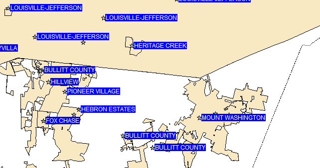
The point labels can display your choice of Policy Number, Jurisdiction Code, Jurisdiction Assigned To, or Street Address to assist you in finding an address easily. The labels can also be disabled. In addition, the Find Address utility can be used to quickly locate any allocated address. When the municipal boundary map contains an excessive number of addresses, the point labels may begin to overlap. To prevent this, clear the "Allow labels to overlap" checkbox. This will reduce the number of labels displayed.
The municipal boundary map can be printed by clicking the Print button on the toolbar while the map is displayed, or by selecting Municipalities Boundary Map from the Print menu.
The address points are graphically representations of the latitude and longitude coordinates plotted to a map. Using the zoom feature to obtain further details will give an inaccurate representation of the coordinates in relation to the municipal or county boundaries.